Friday, August 19, 2011

Animals in a Well of Unified Silla

For our latest entry, we switch gears both spatially and temporally. Specifically, we turn our heads to Korea, and focus on more recent, archeological deposits. During my most recent family trip to Korea, we stayed for a few days in the southeastern city of Gyeongju. While there, we made a mandatory trip to the Gyeongju National Museum, which as luck would have it, is currently housing a special exhibition entitled “Animals in a Well of Unified Silla,” or, directly translated from the Korean, “Fell into a Well Silla Animals.”

My preference is the latter.

To clear up any possible misconceptions, “Unified Silla” refers to a time period, not any physical feature of the well. The Silla Kingdom (57 BCE – 935 CE) was one of the Three Kingdoms of Korea, during which Gyeongju was the capitol, so the present-day city is ground zero for Silla history. The contentiously-named “Unified Silla” occurred towards the end of the Silla (668 CE – 935 CE).

The gory details

(Note: All information provided after this point is from concise museum signs and Google-translated articles, so I cannot guarantee all information made the transition accurately.) Fast-forward roughly a millennia, and a recent excavation of Unified Silla (ca. 810 CE) wells, roads, and fences uncovered one particularly interesting well full of archeological booty [1]. At or near the base of this 10 m well were a plethora of ceramic vessels and bones. Over the course of two years (1998-2000) [2], over 2300 NISP (“pieces” [3]) were excavated, representing taxa including, but limited to: dog, cat, cattle, horse, deer, wild boar, rabbit, mole, mouse, ducks, crow, pheasant, thrush, falcon, snake, frog, shark, puffer fish, cod, mullet, whiting, mackerel, carp, bream, and probably most interesting, a 10-yr old human child [1][4]. A nice illustration of the well is given in unfortunately reduced size to the left [1]:

A number of these bones have been nicely prepared and placed on display in the exhibit. Just looking at the displays provides some taphonomic information, such as the difference between the near-complete representation of cat and dog elements (below) versus some taxa (crow, Korean Water Deer) represented by just one or two elements. (Note again: apologies for pictures that are far from scientific quality – they were taken while walking through a busy, crowded museum.)


Many of the elements also exhibited what appeared to represent wet rot, a poorly-understood corrosion-like modification of epiphyses and spongy bone in element with prolonged exposure to wet or moist conditions (Andrews and Cook, 1985; Andrews, 1995). This can be seen in the vertebrae and epiphyses of the cow elements below:


Also in the cow element display, the rib shafts showed a form of modification that I have never seen before:


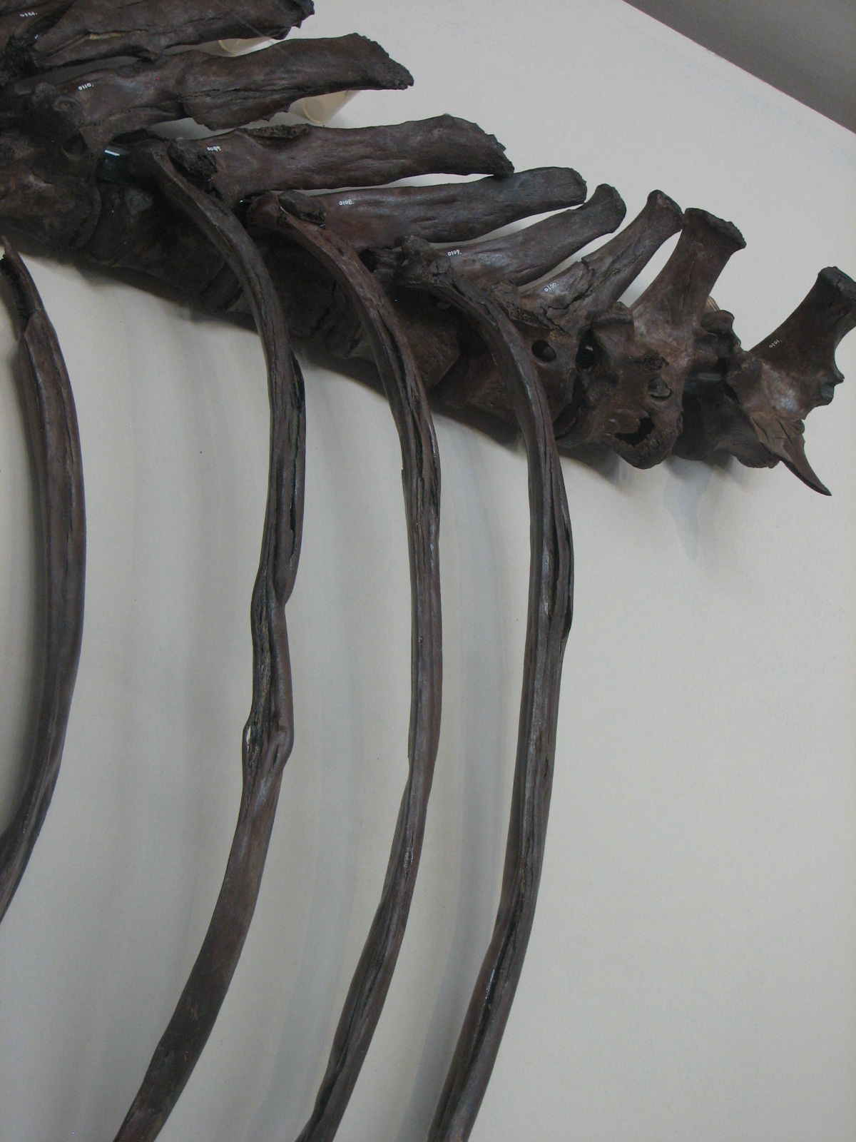
I invite anyone to school me on this phenomenon…

So how did it all get there?

There is little doubt the material in the well was artificially introduced. Nearly all the material is concentrated in the lower 2.5 m, with the very base of the deposit almost entirely ceramic vessels referred to as “earthquake spheres,” and the top of the deposits capped with stamped tile [4]. This suggests all the material was placed at the bottom of the well at one time [1], perhaps for “purification” [4]. There is the possibility that some (perhaps most) of the elements from the subterraneous critters (rodents, moles) may have been naturally introduced, but this can’t be tested without further data. Incidentally, for those concerned about dead animals at the bottom of a water source, it turns out that cold, stagnant water actually does a decent job of hindering decomposition. Besides, just about any natural body of water will have dead animals floating in it.

The inclusion of the child is also the subject of much speculation; one hypothesis suggests he or she may have been victim of drowning, subsequently offered as a sacrifice [1] [4].

Other hypotheses lack scientific rigor...

Hopefully, there will be more concrete explanations soon – allegedly, there is to be a professional publication on the excavation before the end of the year [3].


REFS

1. Gyeongju National Museum exhibition...

2. "Fell into a well Silla animals' exhibition

3. Gyeongju museum fell into a well Silla animals' exhibition

4. Gyeongju Museum exhibition "fell into a well Silla Animals' prepared

ANDREWS, P., 1995, Experiments in taphonomy: Journal of Archaeological Science, v. 22, p. 147–153.

ANDREWS, P., and COOK, J., 1985, Natural modifications to bones in a temperate setting: Man (New Series), v. 20, p. 675–691.

Saturday, March 26, 2011

Probably the Worst Healed Fracture I've Seen

Update: Thanks to reader Mark'o Plenty for pointing out that the femur discussed below is, in fact, clearly avian. And shame on me for blindly assuming it was mammal and never thinking otherwise. Fortunately, this narrows down the list of victims - for a femur that size, the only real likely candidate out here would be a Wild Turkey (Meleagris gallopavo). This would also greatly narrow the list of culprits responsible for the break - most likely, a motor vehicle is responsible, as the galliformes in this area have near-suicidal tendencies with respect to the highways (Scherzer and Peck, personal observation).

After subjecting this blog to what admittedly may qualify as criminal neglect, I return to the business of blogging, with a rather morbid “welcome back” post. I’ve been volunteering at local museum, and recently made an interesting recent discovery in the bone seen here:

That’s the femur of a small mammal – proximal end on the left, distal on the left, lateral side facing the camera - and it is abundantly clear that for a good portion of its life, that mammal was never having a good day. This femur experienced a complete fracture of the shaft – you can see a little window into the marrow cavity at the bottom – which significantly offset the bone, but the animal amazingly survived, and the bone healed. You can see the mass of regrowth where the bone healed along the shaft in the image above, and in more detail below. When examining the picture below, you should also make note of the femoral head (arrow) for later discussion:

The original length of the femur was 90 cm, and following the distortion, this was reduced to a little less than 75 cm, a reduction of almost 20% of the bone length. To put this in perspective, this would be like taking the thigh of the average American adult male (5’ 11”) and shortening it by roughly 3”. The image at left (from here) is probably a good comparison. You may also note some offsetting of the distal epiphysis, perhaps the result of crushing associated with the fracturing of the shaft. This damage to the epiphysis is seen in more detail in the image below:


So who was the victim?

One might naturally wonder what small mammal of Eastern Montana is stoic enough to put the Honey Badger to shame. Unfortunately, the damage to the femur seems to have inflicted some side effects that hinder proper identification. Based solely on gross osteology and original length, I was able to narrow down six possible taxa with the help of Wolniewicz’s field guide of mammal bones (2004): Virginia Opossum (Didelphis virginiana), Swift Fox (Vulpes velox)*, Domestic cat (Felis catus), Bobcat (Lynx rufus), Coyote (Canis latrans), and Domestic Dog (Canis lupus familiaris)**.

* Wolniewicz only provided images of Grey Fox (Urocyon cinereoargenteus) and Red Fox (Vulpes vulpes), but from my understanding, their ranges do not include Eastern Montana, where they are replaced by the Swift Fox, so I made an educated deduction.

** Neither did he include Domestic Dog or Grey Wolf (Canis lupus), but considering the resemblance of the femur to that of the Grey and Red Fox, I figured it was prudent to include the Domestic Dog as a possibility.

But then a visible problem arose - if you look at the femur dorsoventrally (at left), the mediolateral offsetting from the fracture seems relatively minor, hinting that the animal may have tried to use the limb following healing. But closer inspection of the proximal end suggests otherwise. The femoral head pointed out earlier (and visible in the top left of the image to the left), appears abnormally small, as can be seen by comparing it to the femoral head of some of the possible taxa:

(L to R) Domestic Cat, Bobcat, Coyote, Opossum. All to relative scale, all posterior view, femoral head at upper right. Ignore the lines. From Wolniewicz (2004).


In addition, all three trochanters (greater, lesser, and third) are practically absent. I noticed what appear to be rodent gnaw marks where the greater trochanter should be, but the lesser and third trochanters just plain aren’t there. This suggests the animal did not place weight on damaged limb after all, causing the associated muscles, and their respective trochanters, to atrophy as a result. This is good news for some of the taxa that were originally excluded due to their large size, namely the Bobcat and Coyote. A 90 cm femur is unlikely to come from an adult member of either of these taxa, and the fused epiphyses indicated this femur was not from a juvenile. However, a juvenile individual could have broken the femur, and the subsequent neglect would have left it matured but undersized (which is not uncommon). But this is bad news for me, since these trochanters are very useful in identifying taxa, so I was left with a short hand (no pun intended). One tantalizing clue that remains in an unusual groove in the lateral condyle (seen below). This groove is not diagnostic of any North American mammal I’m familiar with, and I didn’t see the feature in any of the images from Wolniewicz (2004). But I would love to hear I’m wrong***.

***Anyone? Anyone?


So what’s the taphonomic connection?

Well, none really. I considered weaving into a discussion on the taphonomic significance of broken bones, or the importance of pathologic features in the fossil record, but I didn’t want to distract from the main focus. A small mammal persevering in the harsh Eastern Montana climate with a deformed and vestigial hind limb is inspirational, if nothing else…


REFS

Wolniewicz, R. 2004. Field guide to skulls and bones of mammals of the northeastern United States, volume 2: the long bones. Richard Wolniewicz Publisher, Magnolia, MA, 97 p.

Saturday, September 4, 2010

An Introduction to the Brule: Awareness of Sheepcamelpig

When we last left Badlands National Park, we had barely begun to scratch the surface, having covered only the Chadron Formation. While respectable in its own right, the Chadron is only a very small percentage of the park. The bulk of Badlands NP (literally) is formed by the Brule Formation – a complex, fossiliferous formation that has been awed for centuries.

Putting the “Land” in Badlands

As I mentioned previously, the Chadron Formation is the lowermost formation in the park, forming “haystack” buttes. The Brule, in contrast, is responsible for the archetypical badlands. The picture above, from the park’s own website shows the cliff-forming Brule in all its glory, with prominent geographic features replete with funny names – castles, fingers, spires, hoodoos, and so on. (You can also see the color banding representative of the paleosols found throughout the formation, a topic worthy of its own blog post in the future…) The dramatic change between the landforms of the Chadron and Brule is very symbolic, as there was a significant change in paleoenvironment recorded in their respective depositional histories.

The transition from the Chadron to the Brule represents the transition from the Eocene (55.8 – 33.9 Ma) to the Oligocene (33.9 – 23 Ma), a period of upheaval (again, literally) in North America and also in the area of the future badlands. To the northwest, the uplift of the Black Hills had peaked, and fluvial systems were carrying the eroded sediment through the area with a vengeance (Retallack, 1983). In addition, in the later stages of the Oligocene, enormous volcanic eruptions in Nevada and Utah were causing vast ashfall deposits on the plains immediately to the west, many of which were picked up and transported by wind into southwest South Dakota (Larson and Evanoff, 1998). In addition, a gradual drying trend afflicted North America during the Oligocene, turning the subtropical environments of the area into savannah-like grasslands. As a result, the Brule is actually subdivided into two members: the lower Scenic member, dominated by fluvially deposited mudstones representing a subhumid environment, and the upper Poleside member, dominated by eolian (wind-deposited) siltstones representing a semiarid environment, both of which are rich in volcaniclastics (Evanoff et al., 2010). The presence of the volcaniclastics makes the rocks of the Brule harder and more difficult to erode than those of the Chadron, allowing the creation of sharp, distinct badlands formations.

Ecologically, the fauna were experiencing some upheaval (not literally, this time) of their own. The extinction of brontotheres at the end of the Eocene marked the beginning of the downfall of the once-dominant perissodactyls at the hands of diverse artiodactyls (Scott and Jepsen, 1940). Which is not to say that perissodactyls were reduced to the role of savannah wallflowers – “rhinos”* experienced their “culminating point” in North America at this time, and the beginning of the infamous evolution of horses began around the same time as well (Scott and Jepsen, 1940). But the ecosystems were clearly becoming dominated by artiodactyls, not the least of which are…

*The quotation marks are intentional. For now, let’s not worry about exactly what that terms means…

Oreodonts: dominant, diverse, damned confusing

Arguably the enigmatic taxa of the Badlands NP, and concurrently the Brule Formation, are the oreodonts (image at left from here), a diverse group of controversial affinity. Two taxa, the small, bizarre Leptauchenia, and larger Merycoidodon, are the most common forms in the park. They have no modern representatives, so are commonly described as “pig-like” or “sheep-like.” As it turns out, they share some features with possible camel ancestors, so “camel-sheep-pig” may actually be more fitting, though no more helpful. They are allegedly the most common large mammals in the Brule Formation “by far,” with Merycoidodon distinguished as “the most common of all badlands fossils” (Prothero and Whittlesey, 1998). In fact, Hayden (1857) originally referred to the Scenic member the “Turtle and Oreodon* beds,” and the Poleside member as the “Leptauchenia beds**.” Furthermore, oreodont fossils are abundant and obvious enough in Badlands NP that they are the most commonly reported fossils by visitors, and not by a small margin (personal observation).

* Again, not a typo. We’ll get to that in a few minutes…

** For the record, naming formations or members by common fossils was not an atypical practice by early geologists at all. This is a thoroughly bad idea for a number of reasons, but unfortunately they didn’t let that stop them, so now we have to deal with the results.

They are also a very diverse group, with an incredible variety in body forms. The aforementioned Leptauchenia, for example, has a markedly unusual skull that caused many earlier researchers to assume it led a lifestyle similar to modern beavers (see Scott and Jepsen, 1940, the source of the images at left). Unfortunately, this diversity has led to a lot of oversplitting (inappropriate naming of new taxa), with a lot of confusing terminology – for example, the name “Oreodon” is the above paragraph is actually an older name for Merycoidodon, an oreodont, and a large number of oreodonts are now classified under the group Merycoidodontidae (still with me?). Robert Carroll’s exhaustive “Vertebrate Paleontology and Evolution” (1988), in fact, doesn’t even list the term “oreodont,” as it is apparently not a valid name for the group. Not surprisingly, the group as a whole is currently undergoing a lot of professional revision (Benton, Miller, Weiler, etc, personal communication, 2010). Regardless, oreodonts are still a fascinating group, and there is much more to say about them, but I will leave that for a future post…


No, you didn't really see this. Keep scrolling.


REFS

Carroll, R.L. 1988. Vertebrate Paleontology and Evolution. WH Freeman and Company, New York, 698 p.

Evanoff, E.E., Terry, D.O., Jr., Benton, R.C., and Minkler, H. 2010. Field guide to the geology of the White River Group in the North Unit of Badlands National Park: a guide for the field trip: recent advances in understanding the geologic history of the White River Badlands, 24-25 April 2010: GSA Rocky Mountain Section Meeting, 21-23 April 2010, Rapid City, SD, USA.

Hayden, F.V. 1857. Notes on the geology of the Mauvaises Terres of White River, Nebraska: Proceedings of the Academy of Natural Sciences of Philadelphia, v. 9, p. 151-158.

Larson, E.E., and Evanoff, E. 1998. Tephrostratigraphy and sources of the tuffs of the White River sequence, in Terry, D.O., Jr., LaGarry, H.E., and Hunt, R.M., eds., Depositional environments, lithostratigraphy, and biostratigraphy of the White River and Arikaree Groups (Late Eocene to Early Miocene, North America): Geological Society of America Special Paper 325, p. 1-14).

Prothero, D. R., and Whittlesey, K.E. 1998. Magnetic stratigraphy and biostratigraphy of the Orellan and Whitneyan land mammal "ages" in the White River Group, in Terry, D.O., Jr., LaGarry, H.E., and Hunt, R.M., Jr., eds, Depositional Environments, Lithostratigraphy, and Biostratigraphy of the White River and Arikaree Groups (Late Eocene to Early Miocene, North America): Geological Society of America, Special Paper 325, p. 39-61.

Retallack, G.J. 1983. Late Eocene and Oligocene paleosols from Badlands National Park, South Dakota: Geological Society of America Special Paper 193, 82 p.

Scott, W.B., and Jepsen, G.L. 1940. The mammalian fauna of the White River Oligocene: Part IV, Artiodactyla: Transactions of the American Philosophical Society, New Series, v. 28, no.4, p. 363-746.


Sunday, August 1, 2010

Why Looking for a Hidden River is like Searching for the Right Asylum

Back in my college days, I was lucky enough to intern at the Cleveland Museum of Natural History for one summer. One aspect of my project involved studying the quarrying history of a local building stone. In the course of my research, I noticed that on many 1800s-era geologic maps, asylums were often located very near to quarries. As it turns out, this was not a coincidence – quarries often hired asylums resident as cheap labor, and in turn, the residents got a chance to leave the grounds and get some stimulation. Hence, a somewhat disturbing lesson: if older geologic maps don’t show quarries, look for asylums. Investigating the geologic record often works in the same vein.

As it turns out, the majority of geologic events in the earth’s history were never preserved in the rock record. Even a geologic event that is sufficiently significant, long-lived, and plainly lucky enough to be preserved may never be discovered – it has to be exposed, accessible, and properly observed and studied. Often, geologic events are not interpreted based on their direct effects, but by side effects and related events. Metaphorically speaking, the quarries are gone, but the asylums remain. In a prime example, in looking for evidence of an ancient transcontinental river in the U.S., geologists had to look in….desert deposits.

How to find evidence of a river nobody can see

Many of the archetypical rock formations of the American southwest – the towering red cliffs, psychedelically wavy hillsides, etc (pictures at left from here) – are the deposits of ancient Jurassic ergs* (sand seas). These ergs were particularly enormous – perhaps rivaling in size the Empty Quarter in the Arabian Peninsula (the largest modern erg) (Dickinson and Gehrels, 2009).

With any erg, the obvious question is “where did all the sand come from”? (Granitic crust is only 1/3rd quartz at most, so a lot of rock has to be eroded to get a sand sea). Two easy answers presented themselves – the (Ancestral**) Rocky Mountains are practically next door, and there were plenty of voluminous sandstones across North America that could have been reworked. But there was also a third possibility, first proposed by Marzolf (1988) – an enormous transcontinental river originating in the Appalachians on the east coast. Unfortunately, Jurassic rocks aren’t exposed anywhere in the U.S. between the Rockies and the Appalachians, so direct evidence of this river was out of the question. But, there are the ergs…

Aspen, Colorado, circa 170,000,000 years ago (from here)

* Deserts and ergs aren’t synonymous, but the two coincided in this instance.

** Not the same as the modern Rocky Mountains, but let’s not get into that right now…

Marzolf’s hypothesis was essentially ignored until University of Arizona geologists William Dickinson (emeritus) and George Gehrels decided to take a look at some of the deposits in the Jurassic ergs in the 1990s. Specifically, they looked at the zircons in the sandstones – unlike the commercials, zircons, not diamonds, are forever in the geologic record, lasting hundreds of millions of years (the oldest known mineral on earth is actually a zircon (Wilde et al., 2001)). Over their long lifespan, zircons can be transported and reworked over thousands of kilometers, but always carry an age signature from their original host rock. When sandstone were sampled from various localities in the ergs, the ages of the zircons fell into three categories: 1/4th matched ages with the basement rocks of the Ancestral Rockies, 1/4th matched ages with reworked ancient sandstones, and the remaining half were divided into four ages too young for the previous two categories (Dickinson and Gehrels, 2003). When the younger zircons were investigated further, it was discovered that the four age ranges fit nicely with….granite bodies that compose the Appalachians (Dickinson and Gehrels, 2009). Furthermore, paleowind measurements from the sandstones showed consistent southern winds (Dickinson and Gehrels, 2009). Combined, this suggested there was some major source of transportation that carried sands from the Appalachians to the western U.S., where they were deposited and carried by winds to build ergs to the south (see cartoon below, heavily inspired by Fig. 1 in Dickinson et al., 2010). And a prime candidate would be….a major transcontinental river!

The long history of Canadian immigration

Recently, Dickinson et al. (2010) tested the "transcontinental river" hypothesis from another angle. I mentioned before that Jurassic rocks aren’t exposed between the Rockies and the Appalachians, but they do exist – under a whole bunch of other rocks. In this case, Dickinson et al. (2010) compared sandstones from the Jurassic ergs to the west to subsurface (fluvial) Jurassic sandstones in the Michigan Basin (star in figure above), an area that would have been right in the middle of some of the northern tributaries of the transcontinental river. This time, the zircon ages were more nuanced: the ergs and the fluvial sandstones both contained zircons with ages matching “Grenvillian” source rocks, but the zircons from the Michigan sandstones lacked ages matching “peri-Gondwanan” source rocks (Dickinson et al., 2010). As it turns out, the “Grenvillian” source rocks are found in northeast Canada, and the “peri-Gondwanan” rocks are found in the southern Appalachians. So it would make sense that tributaries from northeast Canada (upper arrow in figure above) would carry zircons that ended up in Michigan and eventually the western ergs, but tributaries from the southeast U.S. (lower arrow in figure above) would carry zircons that ended up in the western ergs only (Dickinson et al., 2010).


REFS

Dickinson, W.R., and Gehrels, G.E. 2003. U-Pb ages of detrital zircons from Permian and Jurassic eolian sandstones of the Colorado Plateau, USA: Paleogeographic implications: Sedimentary Geology, v. 163, p. 29–66. (pdf here)

Dickinson, W.R., and Gehrels, G.E., 2009. U-Pb ages of detrital zircons in Jurassic eolian and associated sandstone of the Colorado Plateau: Evidence for transcontinental dispersal and intraregional recycling of sediment: Geological Society of America Bulletin, v. 121, p. 408–433.

Dickinson, W.R., Gehrels, G.E., and Marzolf, J.E. 2010. Detrital zircons from fluvial Jurassic strata of the Michigan basin: Implications for the transcontinental Jurassic paleoriver hypothesis: Geology, v. 38, no. 6, p. 499–502.

Marzolf, J.E., 1988. Controls on late Paleozoic and early Mesozoic eolian deposition of the western United States: Sedimentary Geology, v. 56, p. 167–191.

Wilde, S.A., Valley, J.W., Peck, W.H., and Graham C.M. 2001. Evidence from detrital zircons for the existence of continental crust and oceans on the Earth 4.4 Gyr ago: Nature, v. 409, p. 175-178. (pdf here)

Wednesday, June 16, 2010

An Afternoon Spent Packing Heat, or, An Introduction to the Chadron

The focus on Badlands National Park persists, with a post inspired by a recent field outing. In this case, the objective was potentially radioactive sedimentary rocks, but a brief introduction to one of the formations of Badlands NP is warranted:

Act I: A troubled upbringing

The Chadron Formation (32 – 37 Ma) has a troubled history, not unlike many formations in the western United States. It was originally (and still commonly) distinguished by its “Titanotherium beds/graveyards” (e.g. Hayden, 1857; Clark, 1937), referring to the remains of the huge (Asian elephant-sized) animals now called brontotheres (reconstruction seen at right from here). This is a problematic term, as brontotheres are actually rare in the formation (Prothero and Whittlesey, 1998), and the famous “graveyards” may not actually be plural (see Harksen and Macdonald, 1969). Regardless, brontotheres are very large and distinct fossils, and are restricted to the Chadron in the area of Badlands NP, as far as I know. A type section for the Chadron was eventually assigned (Harksen and Macdonald, 1969), but is admittedly of poor quality, and the boundary with the overlying Brule is “basically continuous” (Stoffer, 2003), causing some individuals (including myself) to wonder why they are considered separate formations…

Anyways, the Chadron Formation is one of the lowermost beds in the stratigraphy of Badlands National Park, directly underlying the cliff-forming Brule Formation. It is predominantly green to grey massive mudrocks and (particularly towards the top) thin marls and limestones. It is also relatively shy in the north unit of the park, but is (allegedly) beautifully exposed in the south unit*. Assigning rocks to the Chadron is a rather casual affair in the park, as most poorly consolidated mudrocks of Late Eocene age are uncritically tossed into the formation (Stoffer, 2003). The high clay content in the Chadron causes them to weather into rolling “haystack” buttes, in contrast to the sharp cliff-like buttes of the Brule (image at left from Stoffer, 2003). The Chadron exhibits the last of the environment that existed in the Eocene in the Badlands NP area, documenting extensive streamside forests, low sedimentation rates, and strongly developed paleosols (Retallack, 1983). Also, in contrast to later beds, mammal fossils are most common in channels sands, not paleosols (Retallack, 1983).

* I have not yet explained – Badlands NP has a north unit and a south unit, with a thin strip connecting the two; the park is shaped like a big, sheared dumbbell. And there’s also a chunk of park to the east of the south unit. 

Act II: I defy the basic physics of radiation

Anyways, in the upper Chadron Formation just outside the park boundary in the south unit is an exposure of channel sandstones with uranium-rich minerals at its base. It is suspected that downward-moving meteoric water carried uranium from overlying ash beds until it reached the base of the sandstone, which is underlain by an impenetrable claystone (Moore and Levish, 1955). I made it my duty last Sunday to try and find this exact sandstone. Thankfully, the original publication on the sandstone (Moore and Levish, 1955), includes a marked topographic map and photographs, so I was in luck. After roughly two hours of hiking over distinctly different terrain depending on which side of the tables I was on, I came upon the following exposure (photo from Moore and Levish (1955) on left, with the same ridge marked "A" in both images for comparison):

As I approached the area marked by the arrow of Moore and Levish (1955) (it's in the middle, and very small), the infamous sandstone was exposed in all its glory (backpack at lower right for scale):

I collected a few samples from the base of the (very well cemented) sandstone, but I won’t know if I was truly successful until I find a Geiger Counter or a bored petrologist. Interestingly, some bone fragments were also found nearby, with distinct coloration. Here, for instance is a cross-section of a distal ungulate tibia (cyan book cover background for color enhancement):

The yellow "rim" is notable - bright oranges and yellows are not uncommon for fossils from the area of Badlands NP, and are suspected to indicate the fossils might be radioactive (M. Cherry, personal communication). Considering the nature of the nearby uranium-bearing sandstones, this is not particularly surprising. As I mentioned before, fossils are most common in channel sandstones in the Chadron (Retallack, 1983), and bones commonly show high concentrations of certain minerals relative to the surrounding rocks, due to their difference in porosity. However, while radioactive fossils are not uncommon (e.g. Farmer et al., 2008), I have not been able to find literature that details why these brightly-colored fossils in Badlands NP are specifically suspected to potentially be radioactive. For now, I am left unsure if this assumption is based on mineralogical studies (good) or just color comparison (bad).


REFS

Clark, J. 1937. The stratigraphy and paleontology of the Chadron Formation in the Big Badlands of South Dakota: Carnegie Museum Annals, v. 25, p. 261-350. 

Farmer C.N., Kathren, R.L., and Christensen, C. 2008. Radioactivity in fossils at the Hagerman Fossil Beds National Monument: Journal of Environmental Radioactivity, vol. 99, no. 8, p. 1355-1359. 

Harksen, J.C., and Macdonald, J.R. 1969. Type sections for the Chadron and Brule Formations of the White River Oligocene in the Big Badlands of South Dakota: South Dakota Geological Survey Report of Investigations 99, 23 p.

Hayden, F.V. 1857. Notes on the geology of the Mauvaises Terres of White River, Nebraska: Proceedings of the Academy of Natural Sciences of Philadelphia, v. 9, p. 151-158.

Moore, G.W., and Levish, M. 1955. Uranium-bearing sandstone in the White River Badlands, Pennington County, South Dakota: U.S. Geological Survey Circular 359, 7 p.

Prothero, D. R., and Whittlesey, K.E. 1998. Magnetic stratigraphy and biostratigraphy of the Orellan and Whitneyan land mammal "ages" in the White River Group, in Terry, D.O., Jr., LaGarry, H.E., and Hunt, R.M., Jr., eds, Depositional Environments, Lithostratigraphy, and Biostratigraphy of the White River and Arikaree Groups (Late Eocene to Early Miocene, North America): Geological Society of America, Special Paper 325, p. 39-61.

Retallack, G.J. 1983. Late Eocene and Oligocene paleosols from Badlands National Park, South Dakota: Geological Society of America Special Paper 193, 82 p.

Stoffer, P.W. 2003. Geology of Badlands National Park: A Preliminary Report: U.S. Geological Survey, Open-File Report 03-35, 62 p. (pdf available here)


Tuesday, June 1, 2010

Badlands Background, part I: Soils Past and Present

After a not-insignificant hiatus, blog entries have resumed. For the record, I would personally not recommend starting up a blog before: (1) traveling overseas, (2) getting violently ill, (3) returning home to hurriedly prepare to move to another state, (4) starting a new job, and (5) trying to finalize a manuscript for publication, in that or any order. Regardless, I have recently assumed a seasonal position at Badlands National Park, South Dakota. Due to the literal backyard accessibility and extensive library collections, many of the posts in the near future will likely be focused on Badlands NP geology and paleontology. So, I figured it would be prudent to give a brief background.

The first question, even among practicing geologists, may be “What exactly are badlands?” Unfortunately, “badlands” has come to be defined by consensus rather than by strict criteria, referring to terrain dominated by steep, rugged hills of loose sediment with little to no vegetation. Their creation results from a combination of loose, sandy sediment, sparse vegetation, sudden and intense rainfall, strong winds, and aridity. Despite their nebulous definition, the badlands at Badlands NP have come to be seen as the archetypical badlands due to their size and extent (also thanks to a bit of good timing in their discovery by white men). Incidentally, the name “bad land” has no complicated etymology – that exact phrase, or a slight variation thereof, was historically applied to this terrain by Lakota, French trappers, and English-speaking explorers alike. The same properties that allow for the creation of badlands mean the land isn’t conducive to transport, farming, or habitation, and isn’t a good source of water or oil. Badlands are an excellent source for fossil exposure, however, and are highly valued by paleontologists. Badlands NP, in fact, is worthy of its designation not only for its natural beauty and geologic record, but also for its rich fossil fauna (but more on that later). 

In Badlands NP, the “loose sediment” is over 150 m of volcaniclastic sediment, blown into western South Dakota from eruptions in Nevada and Utah(see Larson and Evanoff, 1998), and fluvially transported into the park between 32 and 28 Ma (Oligocene). Collectively, this sediment composes the Brule Formation, which makes up the bulk of the rugged, colorful badlands seen in the park. As it turns out, the famous colors of the badlands are significant - color banding of rocks in places like Grand Canyon and Canyonlands National Parks are a result of sediment deposited in very different environments, representing different formations. The color banding in Badlands NP is largely confined to one formation, and is caused by paleosols, or fossilized soils (Retallack, 1983). In the picture to the left, for example, the different red, white, and grey bands, as well as the thinner bands sticking out as ledges, represent different paleosols (the brown stakes at the bottom left are 1 m tall, for scale). As can be seen in the picture below, these paleosols can be found ad nauseum in outcrops – in one area, Retallack (1983) found 87 separate paleosols in a 143 m stratigraphic section. Taphonomically, paleosols are great because they represent surface exposure, can indicate the paleoenvironment, and can even hint at whether fossils may be present. But that’s only if you know how to read them, which as I’m learning, is not at all easy (the banding you see on the surface of the badlands, for instance, may have little to do with the actual banding in the rock underneath). Anyways, much more to come…


REFS

Larson, E.E., and Evanoff, E. 1998. Tephrostratigraphy and sources of the tuffs of the White River sequence, in Terry, D.O., Jr., LaGarry, H.E., and Hunt, R.M., eds., Depositional environments, lithostratigraphy, and biostratigraphy of the White River and Arikaree Groups (Late Eocene to Early Miocene, North America): Geological Society of America Special Paper 325, p. 1-14).

Retallack, G.J. 1983. Late Eocene and Oligocene paleosols from Badlands National Park, South Dakota: Geological Society of America Special Paper 193, 82 p.

Wednesday, March 10, 2010

The Awesomeness of Beecher's Trilobite Bed

Trilobites are remarkable animals, deserving not only multiple posts, but probably their own blog (if one exists, I haven’t found it yet…). They are one of the most abundant, well-known, and best-studied organisms from the fossil record. If anyone goes through a “rockhound” period in his or her life, it’s almost a guarantee they picked up a fossil trilobite. For those unfamiliar, trilobites kind of looked like a cross between a pill bug and cockroach (see below), but lived in the ocean. However, 99% of the time, it’s just the exoskeleton of trilobites that is preserved. For better preservation, there are two prime trilobite fossil beds in the world, the Hunsrück Shale of Germany, and Beecher’s Trilobite Bed in New York.

Beecher’s Trilobite Bed is the result of a turbidity flow (think an underwater “mudslide” of very muddy water, image at left from here) which picked up trilobites, carried them a short distance, and essentially buried them alive. For taphonomic reasons, this rapid burial exquisitely fossilized the trilobites as pyrite, fossilizing not only exoskeletons but legs, antennae, muscles, and even internal organs (image below from PDF here). For a more lengthy explanation of how Beecher’s Trilobite Bed was formed, there’s an excellent chapter by Etter (2002), and Cisne’s original taphonomic study from 1973 is now publicly available. But the Beecher bed is a definite taphonomic outlier for a couple reasons, both of which probably need a brief introduction:     

Trilobites were rebels before it was cool

First, in the ocean, only three things are needed to produce pyrite (iron sulfide: FeS2): sulfur, iron, and organic carbon. Chemical studies of the Beecher bed (Briggs et al., 1991) suggest the seawater was already rich in sulfur and iron – all that was needed was organic carbon, readily provided by the washed-in trilobites. Due to the abundance of sulfur and iron, it is plausible that every trilobite (as in, 100%) washed in by the turbidity flow acted as a nucleation site for pyrite and ended up getting fossilized. This is highly unusual – preserving 10% of a paleo-environment would make a paleontologist drool (personal observation).

Second, pyrite can form two ways in the ocean: through “bacterial sulfate reduction” (BSR) or through diagenesis (after burial). BSR occurs in open seawater, while diagenesis occurs in the seabed sediment, with no contact with the seawater above. How the pyrite is derived affects the sulfur isotopes in the mineral: it is commonly thought that BSR-derived pyrite is enriched in “lighter” 32S, while diagenetic pyrite is enriched in “heavier” 34S. Understandably, soft parts (like legs and antennae) decompose faster than hard parts (like exoskeletons), so soft parts would need to fossilize first, right? Well, as it turns out, the legs and antennae of the Beecher trilobites tend to be enriched in the “heavier” 34S, while the exoskeletons are enriched in the “lighter” 32S (Briggs et al., 1991). This suggests the exoskeletons were fossilized first, before burial, and the softer parts stuck around and were fossilized after burial. This is kind of like a root beer float where the root beer evaporates before the ice cream even melts. Briggs et al hypothesized this could have occurred due to changes in water chemistry as the exoskeleton decomposed, but there could be a greater disturbance in the force...

Wait, what do you mean “it is commonly thought”?   

The paradigm on sulfur isotopes, as it turns out, was recently challenged by a publication in Geology led by Justin Ries, a marine geologist at The University of North Carolina (pictured in the field at left, from here). Ries and colleagues examined the sulfur isotopes in a 10 million-year stretch of carbonates from Namibia (Ries, 2009: PDF available at link above). They found that the pyrite derived by BSR was actually enriched in the heavier 34S isotope, enough to be labeled “superheavy pyrite.” Needless to say, this throws a monkey wrench into the current notion that the bacterially-derived pyrite should be “lighter.”

The translation of this article towards the Beecher bed is uncertain – Ries et al attribute the anomalous pyrite isotopes to large-scale (possibly global) low atmospheric oxygen, but it is unlikely such conditions existed when the Beecher bed was deposited. They also consider the anomalous pyrite could have resulted from stratification of the water column, low water levels, or aerobic reoxidation (mixing oxygen back into the water). Personally, I could easily be convinced that turbidity flows, like the kind that produced the Beecher bed, could carry oxygenated water. But, to my knowledge, it’s uncertain how the isotopes of subsequent  diagenetic pyrite would be effected – i.e., could it end up being “lighter” than the bacterially-derived pyrite, or would it be “super-duper heavy”? Like any good scientific study, it creates more questions than it answers… 


REFS

Briggs, D.E.G., Bottrell, S.H., and Raiswell, R., 1991, Pyritization of soft-bodied fossils: Beecher’s Trilobite Bed, Upper Ordovician, New York State, Geology, v. 19, p. 1221–1224. 

Cisne, J.L., 1973, Beecher’s Trilobite Bed revisited: ecology of an Ordovician deepwater fauna, Postilla, v. 160, p. 1–25.

Etter, W., 2002, Beecher’s Trilobite Bed: Ordovician pyritization for the other half of the trilobite, in Bottjer, D.J., Etter, W., Hagadorn, J.W., and Tang, C.M., eds, Exceptional Fossil Preservation: a Unique View on the Evolution of Marine Life, Columbia University Press, New York, p. 131–142.

Ries, J.B., Fike, D.A., Pratt, L.M., Lyons, T.W., and Grotzinger, J.P., 2009, Superheavy pyrite (δ34Spyr > δ34SCAS) in the terminal Proterozoic Nama Group, southern Namibia: a consequence of low seawater sulfate at the dawn of animal life, Geology, v. 37, p. 743–746.